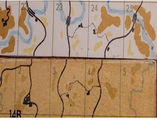
Warplan 5by5 maps how we use and some jargon.
So a look at how you can use the Warplan maps.
Here are the border reaches Daharra and the dual kingdom K & K. 17A and 11B are K&K.
These numbers identify a specific card in the system. You can see 11A is substantially different from 11B. Then the cards are all divided into 25 smaller squares. Hence the reference 17A22 or 14B13 are for specific places. Unfortunate to create game specific jargon, but there you have it.
Let us focus on the actual border area. 17A 21 through 25 on top, 14B11 1 through 5 below.
I am going to concentrate on the K &K side of the border, but the technique is the same on any 5x5 map.
The secret weapon of the Warplan 5x5 is the atlas. Each square is annotated with a short description of what is drawn. You use the awing and description to fully flesh out the table top.
As you can see, there are three roads that go from bottom to top of this map. At the table top level, you want five foot by five foot table to recreate the terrain, So take for example 17A22. Looking up the atlas entry it says in 17A 22 the river ( that "runs deep" ) is crossed by a wooden bridge which will not support the heaviest of vehicles, that there is a cottage and there are some fences present in the square.
Here is a hand drawn map of the table ......if just this one square is of concern, usually the case in smaller actions, suitable for a 6 by 4 foot table. I have added some detail based on the atlas notes.
Notice the scale for the table in the upper right corner. The map is setup with a grid for a 5 foot square table.
I wrote these notes in the key 'so that I would na' haf to remember ' (thanks, Dr. Jones, Senior.)
This is how we locate logistics, adventures and clashes in the campaign. Hope it helps in the upcoming posts.


Comments
It certainly does...look at the right hand numbered square in the top row, 17A25. North of the stream could be a garrison or watch tower or even a keep to control the bridge.
Joe
Best Iain